Showing posts with label Licking County (Ohio). Show all posts

Monday, February 25, 2013

Some Plants from Blackhand Gorge

This is a sort of second part to the first Blackhand Gorge State Nature Preserve post. I stumbled across a few plants that caught my eye on the trip, and took a few shots.

One of my favorite plants, the Diphasiastrum digitatum, also known as Running Pine, Southern Running Pine, Groundcedar, Fan Clubmoss, and a whole range of other common names. This species of Diphasiastrum is the most common in North America. Running Pine used to be harvested as Christmas greenery, and due to its slow growth rate, the populations plummeted. They've rebounded, and now they cover the forest floor in some places. I know that AW Marion State Park in Pickaway County and Davis Memorial SNP in Adams County have large populations, as well as the population at Blackhand Gorge.

Here is a small view of the population at Blackhand. They produce spore-bearing strobili that run higher than the main plant, but there are known in this photo. These strobili look like one central stalk that split into 3-6 upright stalks at the end that are brown on the ends.


This pine-tree-like plant is Huperzia lucidula, or more commonly known as Shining Clubmoss. If you noticed, the previous plant, Running Pine, was also a clubmoss. Clubmosses are known as fern allies, and they are similar in structure to the earliest vascular plants too!

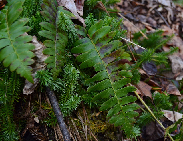
Here's another shot showing some of the Shining Clubmoss jutting out of the hillside leading toward the Licking River. Also, as you can see, there's a few fern fronds here. Now, I am not a botanist, but after researching some and talking to a few other people, we've come to the conclusion that this is Dryopteris marginalis, more commonly known as Marginal Wood Fern. Marginal Wood Ferns are evergreen ferns, and they like cool, slightly acidic soil.


Next, onto this interesting clump of moss. This is a Dicranum moss, most likely
Dicranum scoparium because of its curved leaves. Dicranum scoparium is also known as the Broom Moss or Windswept Moss because of its leaves. I personally love mosses and different looking ones like this always raise my curiosity even more.

Definitely not the best photo, it was more of a snapshot (That ended up blown-out), so excuse that. Anyway, as you can see, a covering of green reed-like plants takes center stage. These plants were kind of going everywhere, which leads me to think this was flooded recently, pushing the normally straight-upright plants aside. So what is this plant?

Here's a close up of the plant. It's a Equisetum hyemale, or Rough Horsetail as we would call it. You might have seen it before, especially if you've been to Clear Creek Metro Park, where it populates the creekside. I've also found it at AW Marion SP along Hargus Creek. Rough Horsetail is found all over North America and is a member of the Horsetail, or Equisetum, genus, which is a "living fossil." In fact, Equisetum plants have been around since the late Paleozoic era, which is pre-dinosaur times. Fast-forwarding to the 2000's, Rough Horsetail is also known as Scouring Rush. Why? Well, the rough bristles on the plant have resulted in its being used as a pot-cleaner, sandpaper, and to shape the reeds of instruments.

I'm very new to plants (I'm a birder mainly), so if I've made a mistake anywhere, please do not hesitate to correct me. Thanks!

Friday, February 22, 2013

Blackhand Gorge and Dawes Arboretum

Monday, which was Presidents' Day, I was able to go on a short day trip since I was out of school.

So, I left Pickaway County for Licking County, specifically for Dawes Arboretum and Blackhand Gorge State Nature Preserve.

I admit, I didn't get too many photos at Dawes. It was really cold, and I was busy moving and did not really want to stop and get photos. Anyway, here's a scene in the forest at Dawes. A light covering of snow was still on the ground. Chickadees, Tufted Titmice, and White-Breasted Nuthatches called from the trees.

We came across a family of White-Tailed deer, including a few young ones. Even though I see deer a lot, it's still a treat to see them.

Dawes Arboretum was spectacular. It was the first time I had ever been there. Dawes Arboretum was established in 1929 by the namesake Beman Dawes and his wife. Nowadays, it has different sections dedicated to everything from Japanese Gardens, to one of the world's largest collections of Holly, to wetlands, to one of the northernmost populations of native Bald-cypress swamps in North America, and a lot more. There are miles of trails and over 5,000 different types of woody plants. It really is an amazing place, and I will have to go back in Spring and Summer.

Next, I went to nearby Blackhand SNP.


This is Blackhand Rock. You might have heard of Blackhand Sandstone, which is the type of sandstone common throughout this area of Eastern Ohio, including the Hocking Hills, here, and so on. It's so called because of what used to be on this rock. The first settlers in this area came across a large petroglyph of a black hand on this cliff side and named it Blackhand Gorge. The petroglyph was Native American in origin (possibly giving directions to nearby Flint Ridge), and sadly it was blasted away when the Ohio and Erie Canal was being built in this area around 1828. The cliffs and rocks were impassible, so the Licking River, which is the river seen here, had to be used to continue through this area. The rocks along the river had to be blasted to make the river wide enough.

This, which I encountered by the Blackhand Rock along the paved biking trail, confused me at first. Later, I learned its origin. This odd, cut path through the hillside is called the "Deep Cut," and it's aptly named. It is 60 some feet high and 700 feet long. It was carved in 1850 and served as a path for the Central Ohio Railroad, which later became the much-more well known Baltimore and Ohio Railroad. 1958 brought this railway to an end as the creation of Dillon Dam required these tracks be abandoned for another nearby route.

There are a few trail options here, including the paved Blackhand Gorge Trail, and the dirt (or in my case mud) Quarry Rim Trail. Here is a photo of part of the old quarry, with the subsequent quarry lake created, as seen from the Quarry Rim Trail. This quarry used to serve as the source of sandstone for nearby Newark, Ohio. The trail winds up from the gorge to the tops of the hills, giving breathtaking views of the sheer cliffs created from years of blasting. It would be amazing to come back in the summer and see what bird species can be found here. All I came across (without really looking) on this trip was a Pileated Woodpecker (the largest species of woodpecker in North America), a Belted Kingfisher, and a few Carolina Chickadees.

This was a common sight all along the Blackhand Gorge Trail. Water from groundwater seepage, gullies, and springs had frozen, covering the hillsides in miniature frozen waterfalls of sorts.

In the end, this was an awesome trip, and I highly recommend going to see these places if you haven't already. Dawes Arboretum is incredibly educational and Blackhand Gorge SNP is steeped in history.

Another post will be coming up soon about some of the plants and animals seen on the trip, so stay tuned!

Edit: Here's the post about some of the plants I encountered!

And one last, not-exactly-nature, thing. The famous Longaberger headquarters outside of Newark. Definitely not what you expect to come across when you're heading down the highway!