Saturday, August 11, 2018

A Journey Through the Watkins Glen Gorge

Watkins Glen State Park is a relatively small park in west-central New York that features an absolutely beautiful shale gorge filled with waterfalls and other wonderful geologic formations. I visited back in early June of this year to hike the gorge and see the sights. In my last post, I did a relatively deep-dive into the geological history of the region and the gorge to put the park into context. If you're a geology buff, I highly recommend checking it out: The Geology of Watkins Glen State Park. This post, however, will examine what the park is like today. So let's go on a pictorial journey down the gorge!

Watkins Glen State Park Spiral Gorge
Beginning of the Spiral Gorge section.
There are several trails at Watkins Glen State Park, including some that go along the edge of the gorge walls, some that connect the gorge with the top of the gorge, and—of course—the trail that follows the gorge itself. The Gorge Trail comes in at around 1.5 miles long. You can access the trail from either the Upper Entrance, which sits at around 1010 feet above sea level, or the Main Entrance, which sits at around 490 feet above sea level. This post will follow the flow of Glen Creek as it cuts its way down the gorge, so we will be going down in elevation. We'll start half a mile down the trail at Mile Point Bridge. Mile Point Bridge (called such as it is a mile up from the end of the gorge) crosses Glen Creek as it begins to enter a section of the Gorge known as Spiral Gorge.

Watkins Glen State Park Pluto Falls
Spiral Gorge is an extremely narrow section of the main gorge that is more reminiscent of the slot canyons out in the American Southwest than anything I've seen in the East. The main waterfall of this section is called Pluto Falls, and it's the small waterfall pictured above. With Spiral Gorge being as narrow as it is, not much light reaches it. This coupled with the steepness of the walls means only the hardiest of mosses can grow on the shale. The darkness and lack of life gave rise to the name Pluto Falls, as Pluto (better known as Hades in the original Greek myths) was the Roman God of the underworld.

Watkins Glen State Park Rainbow Falls
Spiral Gorge soon lets out into a more open section of the Gorge. This immediate section contains the "crown jewel" of Watkins Glen State Park: Rainbow Falls. You can't tell, but this picture was taken from atop a bridge that crosses a big cascade—in fact, you can just see the end of the cascade at the bottom center. The thin waterfall in the center right is the famous Rainbow Falls. As you can see, the water runs down a slick section of the cliffside before falling into the bottom of the gorge. You can also see that the trail actually run behind the waterfall as well. You might be thinking that it doesn't look like much—and you are right, at least from this angle. The view from coming up the gorge is much more spectacular than from going down.

Watkins Glen State Park Rainbow Falls and Triple Falls
If you walk a bit further down, and then turn around, you're rewarded with the most-famously seen angle of Rainbow Falls and the Triple Falls cascade right by it (as well as the bridge the previous photo was taken from). If you look at the Google results for "Watkins Glen State Park," you'll quickly notice that almost all the photo results are of Rainbow Falls from this general angle. It's a common photo, but one that I was longing to take for years, and one that I'm happy I have my own of. I know people sometimes wonder why photographers take photos of places that have been photographed thousands upon thousands of times, especially if it's of the same feature. A lot of times, it comes down to the photographer wanting to have their own version of it, even if thousands of others have essentially the same photo.

Watkins Glen State Park Under Rainbow Falls
The Gorge Trail is fantastic, and one of the unique features of the 1.5 mile trail is not only that you get to see 19+ waterfalls, but you get to walk behind 2 of them! Rainbow Falls is one of the two waterfalls the trail passes behind, and expect to get wet when you go through it. Also, don't forget to tuck away your camera gear.

Watkins Glen State Park Rainbow Falls and Glen of Pools
Just downstream from Rainbow Falls is a section of the gorge called the "Glen of Pools." This section is filled with several potholes and plungepools, one of which you can see at the bottom of the photo above. Potholes and plungepools form from different sets of geological processes, but the end results are similar in appearance: a deep, circular depression carved into the rock. There are two main ways a pothole can form. One way involves the rapid flow of water coming around a curve and forming an eddy. The water will carry sand and pebbles, and over time these rocks will get caught in the eddy and swirl around for a bit. When they swirl around, they carve a pothole. Given more time, the pothole gets larger and larger. Another way involves joints, which I talked about in my last post. If a pebble being carried by the water gets dropped into a joint, the water will swirl that pebble (and others) around in the joint, forming a circular depression over time. The circular depression in the bottom of the picture above, for example, is a pothole.

Plungepools, on the other hand, are associated with waterfalls. Essentially, when water (and any sediments the water is carrying) plunges over a waterfall, the water will hit the bedrock directly underneath the waterfall. Over time, this force essentially digs out a circular depression underneath the waterfall.

Watkins Glen State Park Geology
Further yet downstream, the gorge enters a section that is relatively flat and wide. Why the change? Even though all the rocks exposed in the Watkins Glen Gorge belong to a formation called the Genesee Group, there are hundreds of sub-layers within the formation. Some of these layers are softer or harder than others. The layer exposed in the creek bed above, for example, is harder than other parts of the formation. Because of this, Glen Creek was able to erode down to this harder layer, but was "having trouble" eroding past it; instead, the water followed the path of least resistance and traveled horizontally along the harder layer instead of down and through it. Although after a while this changes once the water does encounter a softer layer that it can more easily erode. At that point, the vertical drops continue!

Watkins Glen State Park Cavern Cascade
As you travel further downstream, you run into what is—in my opinion, at least—the most spectacular formation in the gorge. This is Cavern Cascade. It's a massive waterfall (although not the largest in the park still) that spills out into a deep pool. 

Watkins Glen State Park Walk Behind Cavern Cascade
Your blogger by Cavern Cascade.
Cavern Cascade is also the other waterfall that the trail passes behind. There's a much great volume of water passing in this waterfall, and the roaring sound of the water as it reverberates around the cavernous opening is spectacular to behold. 

Watkins Glen State Park Behind Cavern Cascade
If you stand behind the Cavern Cascade waterfall, you get a real sense of the erosional power of water, and you get to see the impacts this power has had as you stare out over this section of the gorge. All the changes in topography you see in the photo above is due to water and what it does over time.

Watkins Glen State Park Waterfalls
Just downstream from Cavern Cascade—which you can see peeking around in the top portion of the photo—is another, but unnamed, waterfall. At this point in time, the gorge is almost over...

Hiking Watkins Glen State Park
Glen Creek runs through one more narrow, slot-canyon-like section of the gorge, once again highlighting the erosional power of water. This section of the gorge also distinctly highlights the layering found in the Genesee Group.

Watkins Glen State Park Hanging Valley
With one more waterfall, Glen Creek spills out into a wide section of the gorge directly looking into Seneca Valley. Just to the left in this main valleyout of sight in this photo—is Seneca Lake, the largest and deepest of the Finger Lakes. This part of Watkins Glen State Park is the Main Entrance, and it is indeed the main way people enter the park. The town of Watkins Glen is located right outside the gorge opening. The Main Entrance also contains a gift shop and welcome center for the park.
Watkins Glen State Park Trail
Looking back toward the gorge, you would never know what lies in wait from this angle. If you ever find yourself in the Finger Lakes Region, do yourself a favor and visit Watkins Glen State Park. If you do, I have a few tips. There is no entrance fee, but there is a parking fee. However, there is free street parking if you don't mind walking a couple hundred yards extra. Also, get there early. I arrived at 6 AM sharp, and it was literally only me and one other early-rising photographer for the first two hours or so. For a park that attracts over 700,000 people a year, having to share the park with only one other person is fantastic. This park does get busy as the day goes on, but an early visit means you get the park almost to yourself! Also, if you're a photographer, you need a tripod to take decent photos of the gorge. There is plenty of room for a tripod on the wide rock walls of the trail, so you don't need to worry about taking up room on the trail.

As a friend of mine who used to work at Watkins Glen State Park would say: come visit! It's gorge-ous.

The Geology of Watkins Glen State Park

Watkins Glen Rainbow Falls
Years ago, I saw a photo of a spectacular place called Watkins Glen State Park, and I decided that I would—at some point in my life—go visit the park. That chance came this past June, as I was traveling from Maine to Ohio to start a new job. I made a detour into the Finger Lakes region of New York, and spent a morning exploring the park that lies just on the edge of the town of Watkins Glen. Watkins Glen State Park—one of the 215 parks and historic sites operated by the state of New York—sits at the very southern edge of Lake Seneca, the largest and deepest of the Finger Lakes. The main attraction of the state park is a deep shale gorge with over a dozen waterfalls. The geological history of this gorge is incredibly interesting, and this post will dive into that history. We'll explore the geological context of the rock layers that the gorge cuts through, while also examining what forces eroded those rocks to form the gorge itself. After this post, I'll be posting a pictorial walk-through of the gorge, so stay tuned for that post as well for more photos and information about the modern-day park. (UPDATE: Here is the second post: A Journey Through the Watkins Glen Gorge)

When trying to understand and appreciate any present-day geological formation, you have begin with understanding the rocks that the formation is made of. The history of the rocks gives you context for how erosional forces ultimately created the formation in question, and understanding the gorge at Watkins Glen State Park is no different. In a quick-and-dirty summary, fine-grained sediments were deposited in a shallow sea, and these sediments formed a thick layer of a soft rock called shale. Large-scale tectonic forces then exerted pressure on this shale layer, creating thousands of fractures called joints. These joints represent weak areas in the shale, and when glacial and post-glacial forces met these joints, water was able to easily erode the shale and cut a deep gorge over the time span of several thousand years.

Geology of Watkins Glen State Park
Map courtesy of Woudloper, from Wikimedia Commons.
Let’s look at this geological story in greater detail though. Our story begins approximately 380 million years ago in the Late Devonian Period. As you might expect, the Earth looked quite different at this time. Terrestrial plants were just beginning to take root across the world, and early amphibious tetrapods like Tiktaalik were first venturing onto land for short spurts of time. But also occurring at this time—and of importance to this story—was the Acadian Orogeny (orogeny meaning a period of mountain-building). The two smaller landmasses of Avalonia and Baltica had been colliding with the continent of Laurentia, which is the ancient landmass that the modern North American Plate is built around. The collision of these landmasses pushed up layers of rock, forming an ancient mountain range called the Acadian Mountains.

History of Watkins Glen Gorge
Map courtesy of Dennis C. Murphy via The Devonian Times.
These Acadian Mountains were flanked on the southeast by the ancient Rheic Ocean, and on the northwest side by a shallow inland sea called the Kaskaskia Sea. The Kaskaskia Sea covered what is now western New York, western Pennsylvania, Ohio, Michigan, West Virginia, and more. It is in the Kaskasia Sea that our story continues. As all mountain ranges experience, the Acadian Mountains faced erosional forces like rain and wind, and eroded sediments began moving downhill. On the northwestern side of the Acadian Mountains, many streams and rivers were transporting these sediments down the mountains and toward the Kaskaskia Sea. Once these waterways hit the Kaskaskia Sea, they formed a large series of deltas. Geologists refer to these deltas collectively as the Catskill Delta, and the rocks that were subsequently formed from these delta sediments underlay many parts of what was to become western New York, western Pennsylvania, and parts of Ohio and West Virginia.

Linguoid ripples from Kaskaskia Sea in Genesee Group Shale Watkins Glen
If you pay close attention while hiking in the gorge, you can actually see remnants of ripples that formed from the Catskill Delta sediments after they were deposited on the floor of the Kaskaskia Sea. Although these "fossilized" ripple marks are common in the overall rock layers, they can be hard to notice. Luckily, a section of the Gorge Trail exposes some of these ancient hardened seafloor ripples! The photo above shows these ripple marks, and they can tell us a bit about the environment in which they were formed. Due to the fact that the ripples are lobe-shaped, we can tell that the water at this specific point in time and at this specific area had a good deal of energy in it, as the higher energy current created linguoid ripples.

Many of the sediments that were deposited in the Catskill Delta—especially the area that would become western New York—were fine-grained (i.e. small). These fine-grained sediments eventually became fine-grained rocks like shale and siltstone, although there are some thinner layers of limestone and sandstone mixed in as well. The rock layers of the Catskill Delta are incredibly thick, ranging from several hundred feet thick to several thousand feet thick, depending on your location. This large formation is subdivided into smaller layers, and the rocks that are exposed at Watkins Glen State Park belong to a specific slice of the Catskill Delta formation called the Genesee Group.

Genesee Group Black Shale
The Genesee Group is primarily made up of what are known as black shales. As one might guess, black shale is called such due to its dark hue. This dark coloration is thought to be the result of its depositional environment lacking oxygen. Also to note—as this will come into play later on—shales are relatively soft rocks, and are consequently easy to erode.

As the Permian Period began around 300 million years ago, another orogeny took place. This orogeny—termed as either the Appalachian or Alleghenian Orogeny—occurred as Gondwana (specifically the part of Gondwana that would become Africa) collided with Euramerica (the continent that was made of Laurentia plus the newly acquired Avalonia and Baltica from the Acadian Orogeny). A giant mountain range was formed that included the Appalachian Mountains, Ouachita Mountains, Atlas Mountains, and several other associated ranges. The ocean that used to separate Gondwana and Euramerica was also closed up during this orogeny. The resulting Euramerica-Gondwana landmass is known today as Pangea, a name many of you have undoubtedly heard.

Joints Watkins Glen State Park
When this giant tectonic collision occurred, it exerted a tremendous deal of pressure on the rocks of the Catskill Delta formation, including the rocks of the Genesee Group. This pressure cracked these rock layers in thousands upon thousands of areas, creating a multitude of small fractures in the rocks known as joints. These joints come into play later on, as a joint represents a weak area in a rock that can be more easily eroded by water. When you hike through the gorge today, you can see these joints nearly everywhere you look.

Dissected Allegheny Plateau
The dissected Allegheny Plateau.
After the Permian Period, the areas that were to become western New York, Pennsylvania, and West Virginia, as well as eastern Ohio and parts of eastern Kentucky, experienced various cycles of sediment deposition and erosion. By the time that the Cretaceous Period ended, and the Paleogene Period began around 64 million years ago, the land in this area had been eroded down to a broad, flat plain that was criss-crossed by rivers and streams. However, this all changed during the Neogene Period around 20 million years ago. This part of the world experienced a period of uplift, and this flat plain suddenly found itself raised up as a plateau, which we call the Allegheny Plateau. The rivers and streams that criss-crossed the Allegheny Plateau began eroding down into the plateau. Over the next several millions of years, the Allegheny Plateau began to resemble less and less of a broad flat plain, and began to look more like a hilly, dissected plateau.

Geological Formation of Watkins Glen State Park Gorge
Map adapted from Google Maps.
If you were to look at western New York at this time, you would see it was rather hilly with stream valleys in between the hills. Some of these stream valleys ran nearly north-south. These north-south running valleys ultimately became the Finger Lakes that you can see today. But how? Glaciation!

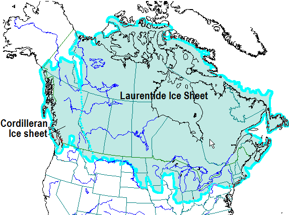
Beginning around 2.5 million years ago, the Earth began a cyclical period of cooling, and a large ice sheet formed at the North Pole. Thus began the Pleistocene Ice Age. During this ice age, the polar ice sheet advanced and retreated in a cyclical fashion nearly two dozen times. Each time this ice sheet advanced southward, it would travel up those north-south running valleys in western New York, making them wider and deeper.

Watkins Glen State Park Hanging Valley
Remnants of the hanging valley carved by Glen Creek as it empties out into the main Seneca Valley. The valley no longer "hangs" above Seneca Valley.
The last glacial advance of the Pleistocene Ice Age reached its max extent around 20,000 to 18,000 years ago. This glacial advance was termed the Wisconsin Glacial Period, and it’s the effects of this glacier which set the stage for the actual formation of the Watkins Glen Gorge. When this glacier was at its extent, the glacial ice had completely filled the Seneca Valley. The glacier did not, however, cover the tops of the ridges that flanked either side of this valley (at least this is what is currently thought by the majority of geologists from what I’ve gathered). A small stream, now called Glen Creek, formed on the western ridge of Seneca Valley, and the water in the creek emptied out either onto the top of the glacier or into a hole in the glacier (we will never know for sure). As the glacier began retreating from the valley, the small stream valley that the Glen Creek had began carving found itself perched above the main Seneca Valley, which was now becoming ice-free. When a smaller valley is perched above a main valley that was carved by a glacial, the smaller valley is known as a hanging valley. (For a visual of what a hanging valley, check out this diagram.) And this is how the Watkins Glen Gorge began.

When it comes to liquid water, it’s really important to know that gravity is forcing water to travel to the lowest point of land it can possibly get to. This is why water flows downhill. This feature of liquid water can create spectacular erosional features, especially if a stream finds itself having to cover more vertical distance than it previously had to. When a stream finds itself in such a situation, it begins to incise (which is eroding downward in a narrow fashion). Stream incision has led to formations like the Grand Canyon in Arizona, or the New River Gorge in West Virginia. And in western New York, stream incision led to the creation of Watkins Glen Gorge.  

Glen Creek Eroding Genesee Group Formation
Glen Creek as it begins cutting into the top portion of the Genesee Group layers.
Starting approximately 12,000 years ago, the water in Glen Creek had to travel from atop a ridge down to a lake—now called Seneca Lake—which had formed at the bottom of the valley. This is a vertical distance of roughly 1,000 feet. As it traveled downhill, it began cutting into the bedrock. The creek soon hit the Genesee Group, which, if you remember, was that layer made of soft shales and filled with joints. This is when things got interesting.

Glen Creek began incising deeply into the shales of the Genesee Group. The joints made it easier for the water to do so, as well. As we mentioned earlier, joints are an area in a rock layer that can be more easily eroded than a solid piece of rock. Essentially, joints allow for water to access and impact a greater surface area of the bedrock than a solid block of rock would allow. Liquid water in a joint can mechanically and chemically weather and erode the rock, and water in the joint can freeze and further crack and break apart the rock as the water expands.

Waterfall Formation Watkins Glen New York
Consequently, many of the awesome formations in Watkins Glen Gorge occur where a joint is or used to be. If you look at the photo above, you can see several joints running up and down the exposed bedrock. You'll also notice that a waterfall formed along one of the joints.

For the past 12,000 years, Glen Creek has been carving its way down through the black shale and siltstones of the Genesee Group, exploiting the hundreds of joints found throughout the bedrock layer. A gorge dotted with waterfalls, plunge pools, and other features has since taken shape. This is Watkins Glen Gorge as we currently know it.

Watkins Glen State Park Nature
When you start digging into the geological history of any place, you soon realize that the place only looks the way it does now due to a specific combination of factors that came together over a long past. The gorge at Watkins Glen owes its existence not to any one factor, but a whole host of them: the sediments in the Catskill Delta laid the foundation and set the scene; the Allegheny Orogeny shattered the resulting rocks and filled them with joints that would be of utmost importance later on; the uplift and consequent dissection of the Allegheny Plateau brought the Genesee Group layers to a perfect location for a gorge to form; the glaciers shaped the area as a whole and the retreat of the last glacier put Glen Creek in the right circumstances for incising; and finally, Glen Creek was able to form the Watkins Glen Gorge due to the erosional power of water meshing with all those other factors that had led up to this moment when the creek met the rocks. Without all these factors and circumstances coming together the way they did, Watkins Glen Gorge wouldn't exist.

Behind Rainbow Falls Watkins Glen State Park
Now that we've done a somewhat deep-dive into the geological history of Watkins Glen State Park, it's time for a pictorial journey through the gorge as it is today. Check out Part 2 of my Watkins Glen posts at this link: A Journey Through the Watkins Glen Gorge

Monday, June 11, 2018

Hiking The Beehive in Acadia National Park

Called by some as the "crown jewel of the North Atlantic Coast," Acadia National Park in Maine is the only national park that can be found in New England. It's a relatively small park by national park standardscoming in at "only" 49,000 acres—but it protects much of Mount Desert Island, the 6th largest island in the lower 48 states. Back in May, a few of the educators from The Ecology School—myself includeddrove the 3.5 hours from Saco, Maine, to Acadia National Park for a weekend filled with hiking and exploring. While there, one of the other educators and I decided to climb the  famous Beehive.

The Beehive Acadia National Park
The Beehive is a granite knob that rises 520 feet above the Atlantic Ocean on the southeastern corner of Mount Desert Island. You can access the summit via The Beehive Trail, whose trailhead is found just near the Sand Beach parking lot. This trail is challenging and offers beautiful views, but it also comes with a much higher risk factor than your average trail. To give you an idea of just what you're climbing up when you hike this trail, take a look at the photo above. The knob pictured is The Beehive. If you look at the zoomed in portion (remember you can always click on a photo to enlarge it), you'll notice a red circle. In that circle is a person, and that person is on The Beehive Trail.

Original figure made by Martin D. Adamiker [CC BY-SA 3.0 (link) or GFDL (link)], via Wikimedia Commons. Figure modified (addition of arrows and text) by Kyle Brooks.
Before we get to what the actual hike is like, I want to spend some time talking about the geology of Mount Desert Island, and especially The Beehive itself. As with many places in the northern portions of the United States, Mount Desert Island was heavily shaped and modified by various glacial periods during the last Ice Age. The last glacial periodthe Wisconsin Glacial Episode—began around 70,000 years ago and finished up around 12,000 years ago. At its greatest extent, this giant sheet of ice completely covered Maine, including Mount Desert Island. In this part of the world, the glacier moved from the northwest toward the southeast. As it moved over Mount Desert Island, it eroded the mountains that were present on the island into long, yet narrow, formations that were separated by U-shaped valleys. 

The Beehive Geology Plucking and Abrasion
Left: A smooth granite face resulting from glacial abrasion.
Right: A jagged, steep granite face resulting from glacial plucking.
As the glacier eroded the mountains on the island, it did so in two different ways, all dependent on which direction the side of the mountain was facing. Take, for example, The Beehive. Parts of The Beehive experienced glacial abrasion, while other parts experienced glacial plucking. Glacial abrasion and plucking are both examples of how a glacier can erode bedrock, but these two types of erosion are a result of different factors and forces. Subsequently, they end up leaving behind different geological features after the glacier retreats. The northwest side of The Beehive was eroded by glacial abrasion. In this case, the glacier smashed directly into the northwest side of the knob. This force of pressure, coupled with the rocks embedded in the bottom of the glacier, smoothed and polished the bedrock like sandpaper on a piece of rough wood. This left behind a large face of smooth, rounded granite.

The southeastern side of The Beehive, however, experienced erosion via glacial plucking. As the glacier polished the northwest side of the knob, it moved over the knob and slid down the southeastern side. As the ice slid down this side, frictional forces caused some of the ice at the very bottom to melt. This liquid water then entered into cracks and joints that were already present in the bedrock, were the water consequently refroze. Since water expands when it freezes, this resulted in large boulders cracking and breaking free of the knob. These boulders were then "plucked" up by the bottom of the glacier, where they were transported and dropped into the ocean or elsewhere. The resulting rock face was not highly smooth and polished, but was instead a steep cliff side with a jagged face. It's on this plucked side of The Beehive that the trail ascends.

Photos of The Beehive Trail Maine
The trail up to the summit starts out easy enough. The trailhead is at the bottom of a gully lined with granite boulders of various sizes—many of which were dropped there after being plucked off the knob by the glacier. This part is straightforward; one just has to watch their footing as they walk from rock to rock and keep an eye out for the blue blazes marking the trail.

The Beehive Trail Mount Desert Island Maine
The boulder field eventually ends at the base of the plucked side of the knob. This is where the scrambling begins. Scrambling is the type of hiking that is in between walking and technical rock climbing. Basically, it's walking up or down a rocky area that requires you to use your hands relatively often, but it still doesn't require technical gear like rope and carabiners.

Metal Rungs The Beehive Trail
This is also the first part of the trail in which you encounter the metal rungs, which you will soon come to rely on. As with many of the steep, rocky trails in the national park system, metal rungs were added at some point along the trail for hikers to more safely navigate. In the case above, metal rungs were added so hikers could safely cross a gap in the rock face.

Sand Beach Acadia National Park
Rather quickly, you are rewarded with grand views of the southeastern side of Acadia National Park. Features like the Sand Beach come into view. Although sandy beaches are not rare in the world by any means, the Sand Beach in Acadia National Park is significant. Maine is not known for sandy beaches; in fact, of the 3,478 miles of shoreline found in Maine, there's only about 40 miles of sand-based shorelines (~1.15% of the total). The Sand Beach in Acadia National Park represents about 290 yards of that 40 or so miles, and the only sand-based beach you'll find on Mount Desert Island.

Climbing The Beehive Trail
While the trail gets higher and higher, and the views get better and better, the trail also becomes increasingly more climbing-based. The trail also becomes smaller, and gaps become more prevalent. At one point a short wooden bridge is required to cross a gap.

Views from The Beehive Trail
Your blogger embracing his inner mountain goat.
Some sections of the trail are very narrow, like the one pictured above. Sure-footing, grippy shoes, and patience are a must.

The Beehive Trail Maine
About halfway up the trail, you reach an "Oh boy" section—at least it was for me. There is a relatively long, and steep, section of the trail that requires lots of climbing up metal rung after metal rung. And to make things more interesting, decades of use by hikers have worn smooth the parts of the granite along the trail, making them slippery. This last half of the trail is extremely reminiscent of the Angels Landing Trail in Utah's Zion National Park. I hiked up Angels Landing in the summer of 2016, and that trail is another example of scrambling up a steep rock face with the use of metal rungs and chains. (Check out my "Hiking Angels Landing" post to see just what I'm talking about.)

Hiking The Beehive Acadia National Park
Leah ascends part of the more steep sections of The Beehive Trail.
Is the trail dangerous and hard to do? Yes and no. All hiking comes with risks. Although The Beehive Trail does have more risks involved than your average stroll through a city metro park, deaths and serious injuries are rare (but they do happen.) The trail itself isn't that strenuous for an average hiker that is at least somewhat in shape and has full control over their extremities. Hiking up the trail and returning via the Bowl Trail (it is not recommended that you descend the way you came up) is only 2 miles, and there's only about a 450 foot elevation gain in total. That's not much at all in the hiking world. The biggest challenge hikers face is the fear factor. Afraid of heights? Well, this trail might not be for you. I've heard stories about hikers getting halfway up the trail, only to become frozen in fear. The only way out is up, though.

The Beehive Summit Marker
If you don't mind heights and cliff sides, and you're willing to do a bit of non-technical climbing and scrambling, then you'll love this trail. It's absolutely beautiful, and it's been one of my favorite hikes that I've done east of the Mississippi River.

Kyle Brooks Nature Writer
Even though the summit is only at 520 feet above sea level, The Beehive sits on the edge of the Atlantic Ocean, so the views are fantastic. You can see miles and miles of the ocean, Mount Desert Island, and the mainland. If you ever find yourself in Downeast Maine, head over to Acadia National Park and hike The Beehive; you won't regret it!

Update: Back in Ohio

Hello Again Folks,

As I wrote back on March 24, I had been living in Saco, Maine to work for The Ecology School as an ecology educator for their spring term. Sadly, the amazing season came to an end on June 8. The good news is that I will be transitioning to a new job in a few days.

For the next year, I will be working for the Greening Youth Foundation as a public affairs intern specializing in photojournalism at Ohio's Wayne National Forest. As some of you might remember, I previously worked at Wayne National Forest as a wildlife biology intern. I'm very excited to be working at Wayne National Forest again, and I'm also extremely excited to be trying my hand out at photojournalism in a more professional sense (as I already have been doing so on an amateur level for years).

As such, I'll be living once again in southeastern Ohio, near the Athens area. I'll also have a lot more time for blogging, as working at an environmental education camp tends to suck up all your free time. In fact, I have several posts in the works as of now, so keep your eye out for them!

Saturday, March 24, 2018

Update: Temporarily Living in Maine!

Saco Bay Beach, Maine
Hello all! I've got a quick life update. If you're a longtime reader of this blog, you might have noticed I haven't been posting as much recently. That's not due to me giving up on the blog or anything; instead, I've been incredibly busy and haven't been able to make the time to write.

Last weekend, I made the move from Athens, Ohio, to Saco, Maine. I will be working the spring season for The Ecology School as an ecology educator. I love environmental education, and so I'm very excited for this opportunity. However, working at a residential science education camp is very time consuming, and I will be struggling to find the time to write blog posts at the pace I want. It also doesn't help that I don't have easy access to WiFi where I will be living. Because of this, any new posts will be made very sporadically until the end of the position (June 8th).

Thanks for reading!

Wednesday, February 21, 2018

My 2017 Amphibian Review

This past week, temperatures in Ohio soared into the mid-60's, and rain soaked the ground. Although it was still a bit early, some of the salamanders and frogs across the southern half of the state decided they would attempt the journey from their overwintering territories to their vernal pools in hopes of breeding. Their attempts were premature—the weather soon dipped below freezing, and a snowstorm moved across the state—but it got me excited for springtime. To get me through the remaining days of winter, I've decided to put together two posts reflecting on some of the species of amphibians and reptiles I saw last year. I'll start with the amphibians, as they are the first of the "herps" to become active during the year.

Spotted Salamander Ohio
Every year, people from around the eastern US look forward to the annual salamander migration. Throughout the forests of the east in the early spring, several species of salamanders belonging to the family Ambystomatidae venture forth from their subterranean homes and migrate upwards of a mile overland to reach vernal pools and ponds to breed in. This event is triggered by the weather, and it typically occurs the first night in spring in which the soil is not frozen, the air temperature remains above 50 °F, and it is either raining or it had rained all day and the ground is still wet. In southeast Ohio, "the night" happens most often between mid-March and the beginning of April. But 2017 was an abnormal year; we experienced extremely wet and warm nights toward the end of January and throughout February. This triggered some, but not all, of the salamanders to migrate early, such as this Spotted Salamander (Ambystoma maculatum) which migrated to a vernal pool on the night of February 7th, 2017—over a whole month earlier than what it normally would.

Jefferson Salamander Ohio
The Spotted Salamanders weren't the only migratory species to be out the night of Feb. 7, 2017. This Jefferson Salamander (Ambystoma jeffersonianum) was also making his way to a vernal pool. Migrating early, especially if a cold snap occurs right after, can be quite harmful for such migratory salamander species. Right after that night, people posted photos of vernal pools full of dead Jefferson Salamanders late last winter—they had frozen to death. Such instances will most likely increase in the future, as Ohio will face an increase in abnormal weather patterns due to climate change. Ohio is predicted to experience higher winter and spring rainfalls and warmer winter and spring temperatures over the next 100 years, and this will undoubtedly affect migratory salamanders.

Just how it will impact the salamanders is uncertain, but the end effect will more than likely be detrimental. Warmer temperatures and rainfall events earlier in the year will most likely trigger Ambystomatid salamanders to migrate earlier and breed earlier. In addition to the possibility of freezing to death due to the ever present threat of cold snaps in late winter, we could also possibly end up seeing an "out-of-sync cycles" effect, in which the salamander larvae are in the vernal pools, but their food might not be there. We are already seeing this occur with various species of birds. Migration in birds is relatively fixed and triggered by the amount of daylight. Their migration is supposed to be synchronized prior to the peak of mass insect activity so the nestlings will have abundant food available, but insect activity is happening earlier and earlier due to climate change. This is resulting in birds migrating to an area without that much food, and nesting success is decreasing because of it. Could we see such a problem arising with migratory salamanders? Although it’s too early to tell, it’s something herpetologists will be keeping tabs on over the years.

Northern Slimy Salamander Ohio
Not all salamanders migrate; in fact, the vast majority of species don't. For example, of the 24 species of salamanders which can be found in Ohio, only 7 migrate. The others are either fully/mostly terrestrial or fully aquatic, and they breed where they live. One of the more common terrestrial and non-migratory salamanders in the state is the Northern Slimy Salamander (Plethodon glutinosus glutinosus). This species can be found throughout the southern and eastern halves of Ohio. Their name stems from their defensive behavior; if a predator (or a curious human) messes with a Slimy Salamander, the salamander will excrete this incredibly sticky and glue-like secretion from its skin. It will then try to rub this secretion all over the potential threat, which will hopefully deter whatever that threat is.

Red Salamander Ohio
One of my absolute favorite salamanders to see is the Red Salamander (Pseudotriton ruber). This species is a large one, with adult individuals coming in at 5-7 inches in length! The Red Salamander can be found throughout the eastern half of Ohio, where it spends its time either hiding under rocks and logs alongside forested brooks and springs, or within the water itself.

Red Eft Red Salamander Mullerian Mimicry
You might be wondering why it would benefit a salamander to be so vividly colored. Wouldn't a large red and black salamander scream "EAT ME" to predators? Well, it's actually the opposite! Bright coloration can be a sign of toxicity. Such conspicuous coloration/patterning is called aposematic coloration, which is more commonly known as a warning coloration. The Red Salamander, for example, has a toxin located throughout its skin which makes it poisonous to potential predators. As a result, the species evolved aposematic coloration to warn predators that messing with them is probably a bad idea. But there's something more complex going on than just simple aposematism. Several salamanders in the eastern US have evolved a similar red/orange coloration with black dots, and it seems to be a case of mimicry. Take, for example, Red Salamanders, Mud Salamanders, and the Red Eft stage of the Eastern Newt. All three of these species are toxic, and they have all converged on a similar red/orange coloration with black dots. This is a case of Mullerian mimicry, in which two or more toxic species converged on a similar appearance. The evolutionary idea behind Mullerian mimicry is that predators will only have to learn to associate one type of coloration with danger, despite there being 2+ toxic species in question. Mullerian mimicry benefits both the toxic species—which are more likely to be recognized as dangerous—and the predators—which are more likely to recognize the danger.

Long-Tailed Salamander Ohio
One last salamander! Meet the Long-Tailed Salamander (Eurycea longicauda). For years, this species had evaded me; and then 2017 happened. Not only did I see my lifer early in the summer, but I ended up seeing several more throughout the year, including 3 on one day! As the name implies, the Long-Tailed Salamander has an extremely long tail relative to its body; in fact, the tail typically accounts for around 60% of its total body length. They're a strikingly beautiful species, but it can take some searching to see one. The Long-Tailed Salamander can be found throughout southern and eastern Ohio, where they typically inhabit limestone or shale-based streams, caves, and springs. While the adults are terrestrial, the larvae are fully aquatic, and so the adults typically live close to appropriate aquatic habitats. In such appropriate locales—typically alongside streams or nearby seeps and springs—they spend their day foraging underneath rocks and logs. The individual pictured above was found in Adams County, where it was living under a limestone rock by a stream with a limestone bed.

Eastern Spadefoot Ohio
It wouldn't be a post on amphibians without mentioning frogs, so I'll end on with the most exciting amphibian species that I saw in 2017. This is the Eastern Spadefoot (Scaphiopus holbrookii). The Eastern Spadefoot is a notoriously hard species to see in Ohio for two reasons: their rarity and their life history. Regarding its rarity, the Eastern Spadefoot is listed as Endangered in the state of Ohio. Although it's hard to find exact information on their current range in Ohio—different organizations don't seem to agree on which counties have and don’t have populations, and just how many of those populations are extinct and extant—it can be safely said that this species has only ever been found in a handful of counties. Of those recorded populations, many have died out over the past century due to a variety of reasons, both known and unknown. ODNR reports that only 5 distinct populations of the Eastern Spadefoot remain in Ohio, and no one really knows how how many individuals are in each of these populations.

Scaphiopus holbrookii Ohio
Regarding its life history, the Eastern Spadefoot has a lifestyle that makes it rather difficult to go look for, even if you know exactly where a population is. The Eastern Spadefoot is an explosive breeder that's more akin to frogs inhabiting the desert southwest. For nearly the entirety of the year, this frog stays underground, where it lives in burrows in sandy areas adjacent to a few rivers in southeastern Ohio. When they're underground, they're essentially impossible to detect. They only emerge to breed, and breeding is triggered by very specific weather conditions. If there is a torrential rain event of 2+ inches of rain within a 24-hour period between the months of March and September, dozens and dozens of individuals might venture forth from their subterranean homes come nightfall to breed in the ephemeral pools the heavy rainfall created. The individuals pictured in this post were found on a visit to a known location in Athens County (all locations are kept secret to prevent unnecessary strain on the population) after nearly 2.3 inches of rain fell over the course of one and a half days.

Eastern Spadefoot Burrowing
Eastern Spadefoots are strange. They look strange, they sound strange, and they have a strange life history for a frog species that lives in the eastern US. The unusual name of "spadefoot" comes from a darkly-colored, hardened spur on their back legs that they use like a spade to help them dig into loose, sandy soil. With use of this specialized "tool," a Spadefoot can easily—and quickly—burrow into the soil, like the individual above. I couldn't get a photo of the spade (because the Eastern Spadefoot is endangered, it is illegal to touch the animal), but here is a link that will show you what I'm talking about: Spadefoot spade.

In a few days (or a couple weeks) I'll be posting the second installment covering some of my favorite reptiles from 2017, so keep your eye out for that post! Thanks for reading!