Monday, January 27, 2014

A Snowy Winter Hike

Hey everyone! This winter has proved to be a real winter so far, unlike the past couple of years. I know many are probably longing for the warmth of Summer and everything that comes with it, but personally I love the winter. Yes, it has been a tad colder than what I would prefer (walking to class with a windchill of -16 was surely interesting), but I've definitely enjoyed this winter so far. As I write this (January 27th, 2014), another Arctic vortex is making its way into the state, bringing temperatures that could hit as low as -30 with the windchill.

This past Saturday, however, I headed up to The Ridges to do some hiking in the snow-filled forests. Most of Ohio had experienced a snow storm Friday night into Saturday morning, and Athens received around 4-5 inches from what I saw.

I began my hike on part of the Nature Trail. I was not the first person on the trail that day, as multiple footprints showed many others had hiked around the area since dawn.

I soon found a pristine trail that no one had traveled that morning. Well, at least I use it as a trail. I think it's a pipeline-right-of-way and not technically an official trail, but construction crews had cut a pathway through the brush and trees this past Summer and I've been using it as a trail ever since.

The Pipeline Trail, at least that's what I call it, eventually leads to this broad and long opening. In the summer it's a massive grass field, but as you can see now the grass is gone (they actually cut it short in late Autumn) and it has become one giant snow field. As you know, animals leave prints in snow, which in turn allows you to see travel patterns. In this instance, all the tracks were confined to the edges of the forest. This makes sense; no animal wants to be exposed out in the middle of the field with no cover. Not one set of tracks could be found crossing the field.

Following the field, you end up on the Radar Hill Trail, which cuts perpendicularly across the field. I followed that trail to its namesake. This shot was taken atop Radar Hill. Snow covered foothills can be seen a couple miles away in the background. While I was hanging out on top of the hill, admiring the sights, some snow moved into the area...

...And within a few minutes I was in the middle of a snow squall. Look familiar? This photo was taken in the same place facing the same way as the previous one. With the whiteout conditions, the hills faded into oblivion, and even the trees almost faded completely.

After a few minutes of enjoying the serenity and isolation that the snow squall brought, I began heading back down the trail. The snow continued. The wind howled mercilessly, whipping the falling snow into swirling vortexes. It was truly amazing to be in. I learned a side-effect of being in a snow squall like this is looking like a snowman when it's all over!

Eventually the snow stopped as the sun began its way toward the horizon. The last leg of the hiking trip took me through a snow-blanketed forest with Dark-Eyed Juncos, Carolina Chickadees, and Tufted Titmice foraging all around me.

Honestly, I'm starting to really love Winter hiking, a lot. I've never done it really until this year, and it's very enjoyable if you prepare correctly. I actually overdressed on this trip and had to take my coat off because I was too hot, even though it was in the teens with windchills even lower. The key is layers; not just one thick, heavy layer, but many lighter, smaller layers. For example, I was wearing a base-layer long sleeve shirt, a short sleeve shirt, a sweater, and then an insulated flannel jacket along with two layers of active-wear long underwear with a water-resistant pair of sweatpants which I tucked into my boots. As for footwear, I wore two socks (a regular pair and a wool/synthetic pair) and water-proof Goretex boots. This kept my feet warm and dry, and the rest of my body was warm as well. Plus, if you get hot while wearing multiple thin layers, you can always take them off accordingly until you're at a perfect temperature. Wearing only one big layer prevents this; you either wear it and sweat, which is dangerous, or you take it off and freeze, which is dangerous. So, LAYERS!

Sunday, January 5, 2014

Witches and Bong Hill

Now that winter (and finals) has come, I've been looking through some previous photos from fall to get more posts. This post is about two of the well-known hills in the city of Athens, in Athens County, Ohio.

I've previously made a post on probably the most famous hill in Athens, called Radar Hill, including a post on some of the things I found at The Ridges and Radar Hill. This post will be a quick overview of Bong Hill and Witches Hill.

Bong Hill Athens
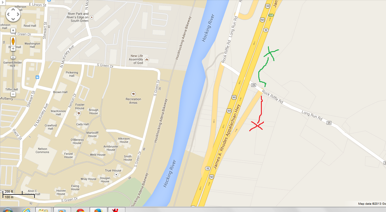
Okay, I know, horrible MS Paint skills. Here's a rough map to where they're located. The left portion is Ohio University. The Red Line is Witches Hill, and the Green Line is Bong Hill. There's a small pull off by the Bong Hill trailhead on Rock Riffle Road, and the trail is pretty easy to find. Witches Hill's trailhead on the other hand isn't so easy to find at first; I wandered around for about 5 minutes trying to find it. It is actually not on Rock Riffle Road, but on the off ramp. It is really close to the stop sign at the intersection of the off ramp and Rock Riffle though. Look closely at the hill and you'll see a very, very steep trail to Witches.

Bong Hill Athens
First up, Bong Hill. Why is it called Bong Hill? Well, I've heard a few stories. The obvious story is that it got its name from the stoners that supposedly hang out on it. I've also heard that story is a myth and it's actually named after an old Ohio University professor. Whatever the reason, this hill offers a great overlook of the city of Athens. The trail is not easy; it is steep and very rocky in places. The trail ascends around 200 feet in less than a quarter of a mile (actually about .19 miles or so). Some minor rock scrambling is involved in certain parts along the trail, like having to pull yourself up onto a rock too large to just step onto. Nothing too bad, but bring water!

Bong Hill Athens
After you make the climb, the trail opens up to a small clearing. The opening overlooks the city of Athens. It's an amazing view.

Witches Hill Athens
Now to Witches Hill. Sorry for the overexposed photo. Anyway, this is part of the trail that leads up to Witches Hill. The trail for Witches Hill ascends around 250 feet in about .18-.2 miles. The trail itself is longer, but it's mostly flat once you get up there. The ascent is very steep and can be a bit dangerous depending on conditions, so be careful.

Witches Hill Athens
Witches Hill is known in the area as a really good bouldering location. I know nothing about bouldering, but I met two climbers who had come from Ohio State University (nearly a 1.5 to 2 hour drive away) in order to do some climbing after they heard how good of a location it is. You can actually see them farther down the trail in this photo. The top of the ridge is covered in massive rock faces, boulders, and more. If you expect to hike this trail, be ready to have to climb some rocks as the trail sometimes jumps up a rock face or down one. It's nothing too crazy though.

Witches Hill Athens
Here's a photo to give you an idea of how large the boulders are, with yours truly as a size reference. (Fun Fact: Getting this photo terrified me. I had to set my camera on a self timer and crawl out on a log in time for the photo, all while being about 15 to 20 feet above the ground.) Obviously, please use common sense on this hill and don't do anything stupid.

Witches Hill Athens
At the end of the trail is a nice, and decently large, rock shelter. Apparently this place is used occasionally as a party location; there were broken beer bottles everywhere. There is also a fire pit that has years of ash built up. It must have been used recently because it was still hot the day I visited.

Ohio University Hiking
What about the view from Witches Hill? It's one of my favorites. This is looking toward uptown Athens, but shows some of campus. You can also look out the other direction and see more of Ohio University. It's a great view, and well worth the hike.


That's it for this post. Sorry I've sort of disappeared for a few weeks on here and my twitter. I've recently been really busy. Hopefully I'll be more active in the coming weeks and months! Happy New Year to you all as well!

Sunday, December 15, 2013

Tracks in the Snow

Saturday the 7th brought a lull in two back-to-back snowy days, so I decided to head out after lunch to The Ridges in Athens, OH, to get some relaxation in before finals week and see what I could find.

The snow wasn't too deep; in fact much of the gravel trail had already melted in places, but the forest floor was still covered as you can see. I was the first human on this trail, but far from the first animal.

One of the first tracks I came across, and one I wanted to share, were these. These are the tracks of a Wild Turkey, Meleagris gallopavo. Notice the distinctive shape. These are large prints and definitely stand out from the other tiny, half-inch songbird prints you might find around. I had not found turkey at The Ridges before, but had assumed they were probably in the area. Finding these tracks confirm my suspicions, and now the next step is to see them.

While at one of the cemeteries along the trail, I came across these tunnels. They were very small, but what made them? I'm not exactly sure, but I know it was either a vole, mouse, or shrew species. Come snow fall, those tiny mammals are probably happy to be able to hide in tunnels they dig all around instead of being exposed.

I came across these tracks a few miles in on the trail. They were grouped like this and went across a bridge and off into the forest. There was a decent sized gap in between these "clusters" of tracks, meaning whatever it was was running over the bridge and into the forest. So what made these tracks? Well, there was some snowfall in the tracks so they weren't the crispest which made it hard to see all the details that would make an ID easy. Also add that to my little knowledge of animal tracks, and you have a stumped blogger. I knew it was some sort of carnivore, specifically a canine or feline species, but that was it.

So I posted these photos on the Facebook group Mammals Ohio for some help. In comes naturalist Joe Letsche. He said he "Can't say for sure, but they appear to be Red Fox tracks based on the trail width, the oblong shape of the track outline, and the gait. Bobcats rarely run unless they are chasing something or being chased." I had originally thought it might have been Bobcat tracks because there are supposedly multiple Bobcats at The Ridges; however, after comparing these and Red Fox tracks, I agree with Joe Letsche in this most likely being Red Fox Tracks.

I also found hundreds of deer tracks, raccoon tracks, and some songbird tracks on the trip, but I didn't get photos of them. Also, since my first semester is over, I will have some time to go back and write some more posts on photos I might have saved away, so keep on the lookout!

Monday, December 2, 2013

IMPORTANT MESSAGE: On bird conservation in the Lake Erie region

Hey guys! This is an important issue that needs action!

There has been a push to build wind turbines along Lake Erie. This seems like a good move as it promotes green energy; however, people are failing to realise the ecological damage this would result in.

Location is key with wind turbines. Wind turbines create vacuums behind the blades which suck in and crush flying animals, such as birds and bats. Lake Erie is an important flyway for many species of migrating birds, and these wind turbines would result in the deaths of thousands of birds every year for as long as they would stand. While it is green energy, the ecological harm these turbines would cause would be catastrophic and undo much of the "green" part of it.

Kenn Kaufman, whom you may know from Kaufman Field Guides, at the Black Swamp Bird Observatory in Ohio has created a petition to stop these turbines. Please take a moment and sign it. The instructions are below:

"Black Swamp Bird Observatory would like to invite all you to register your objection to wind energy development in the highly bird-sensitive areas of Ottawa County, Ohio, specifically the wind turbine projects at the Camp Perry Air National Guard facility and the Lake Erie Business Park.

Rather than an online petition, we opted for a special email address at BSBO where we offer a 100% guarantee that we will not sell your information to advertisers! Your information will ONLY be shared with elected officials.

Please follow these instructions to the letter to save the BSBO staff time and effort.

1) Send an email to: ResponsibleWindEnergy@bsbo.org

2) Put 'RWE' in the subject line

3) In the body of the email, include the following information in this exact format:

Name
City, State, Zip
Email Address

4) OPTIONAL! - A brief comment (1 - 3 sentences) about why you object to wind turbines in these bird-sensitive areas.

The BSBO staff will create a spreadsheet with all of this information and include with our second official letter of opposition which we will send to elected officials. Thank you so much to all the caring birders out there! YOU are the key factor in swaying the opinion of these elected officials!"


Thanks for reading. Remember, we are the ones who must help protect the Earth from the others wanting to destroy it (even if it may be from ignorance). Do not sit idly by; do your part, take action.

These birds and more would be at risk from wind turbines that would be located along Lake Erie.
 

Monday, November 25, 2013

Hocking Hills Trip

So Friday night (November 22, 2013), the Ohio University TravelCats headed out on their first ever trip. The trip was simple enough; rent a cabin in the Hocking Hills region of Ohio for Friday and Saturday night, and hike Saturday and some Sunday in the Hocking Hills State Park. Who are the "TravelCats?" Well, the TravelCats is a club that was just started this year with the idea to bring together people at Ohio University who love to travel so we can talk to each other and learn traveling tips, and hopefully even plan trips to take with other members. Here is the TravelCats blog if anyone is interested.

My main goal was photography on this trip, so pardon the lack of creatures and so on like my posts normally have. Be warned, this is sort of a "mega-post."

The first stop Saturday was Old Man's Cave, which is one of the multiple "mini parks" of the large Hocking Hills State Park. Old Man's Cave is definitely the most popular part of the park, and visitors are greeted with a three tiered parking lot that can completely fill some days. It's one of the most popular hiking destinations in Ohio, and for good reason. The area is beautiful. The central feature to Old Man's Cave is a carved out gorge with waterfalls, rock formations, and more. This is one of the main features: The Devil's Bathtub. The stream cascades down into a deep pool that is a few feet deep, before flowing back out into the normal stream.

As we hiked from The Devil's Bathtub up the gorge, we came to the beginning of the gorge, marked by the Upper Falls. The recent heavy rains had swollen the stream, and the waterfalls were really flowing. Back when I visited in August, this waterfall was only a trickle. Above the waterfall, just out of frame, is a stone bridge that gives visitors a view of the falls and the pool from above.

We turned around and began heading back past The Devil's Bathtub and on to the area of the Middle Falls. These cascades begin the Middle Falls area, as they continue off frame and over a small waterfall. These cascades are always beautiful, but the lighting is normally harsh and as a result I've always struggled to take a decent photo. Finally, with the sky overcast, I was able to get a photo of this exact area I liked...after 4 years of trying. Go persistence!

And of course, if there's an Upper and Middle Falls, there's got to be a Lower Falls too, right? And that's what this photo is of. The Lower Falls flows over the rock and into the air before falling into a really expansive pool of water.

Next we headed on over to Conkle's Hollow State Nature Preserve. While nestled in the mid section of the Hocking Hills State Park, this is a separate Nature Preserve and notice that because of that, there are different laws. One I see people constantly breaking (even though there is a decent sized sign right at the very beginning of the trail) is the "No Pets Allowed." All State Nature Preserves have this law, and people constantly bring their dogs to Conkles Hollow. Please don't. But anyway, we decided to opt out of the Gorge Trail due to time constraints, and focus solely on the 2.5 mile Rim Trail.

The gorge in Conkles Hollow is one of, if not the deepest in Ohio. The 200 foot cliffs are some of the highest in Ohio. The Rim Trail is absolutely spectacular, but definitely not for one who fears heights or small children. I want to stress that. For much of the trail, you are literally about 1-2 feet from a sheer 200 foot cliff. People die here on a regular basis, and, to be blunt, it's essentially all from acting stupidly around these dangerous cliffs. Otherwise, this trail is incredibly beautiful with amazing vistas. If you are a hiker, I strongly suggest doing this trail.

While halfway through the trail, much to our delight, it began snowing. Flurries at first, but then it started up in earnest and immediately stuck to the ground. The sight was amazing; looking into the gorge revealed swirling snowflakes as they traveled to the ground and snow-covered hemlocks. It was truly beautiful, and we had no idea snow was even a chance that day.

Sunday we headed out to do a quick hike at Cedar Falls. It was freezing that day; I had put my tripod in the water to take one photo, and the water made the legs freeze up within two-four minutes after that. Cedar Falls has the highest average output of water of the waterfalls in the Hocking Hills, and it was definitely a sight, and a sound, from the recent rains; you could hear it from the parking lot! Anyway, here is a shot of the falls, along with one of the founders of TravelCats in there as a size reference for the falls (she's on the lower left side).

Here's a side view of Cedar Falls. As I said previously, you could hear the roar of the falls from the parking lot, and this show gives you a good idea of why. You can also see some of the icicles that were everywhere around that area of the park.

Last photo! Here's the members of the TravelCats that went on this trip. The co-presidents are the two in the middle, and your blogger is on the right end. Future trips currently in the planning stages for TravelCats include a possible Seattle trip, with a visit to Olympic National Park (which is at the top of my bucket list).

Anyway, hope you enjoyed! And one final plug. I recently made a Facebook page for my photography. If you like my work, check it out! You can see other photos not posted on here, and even buy prints if you're interested. Click on this link to visit "Kyle Brooks Photography!" Thanks again, and keep tuned; there are more posts in the works!